When I first arrived here at the Picketpost Mountain Trailhead I posted about hiking the trails. In the post Arizona Trails, I said that I would return to the Picketpost Trail and reach the summit. With a week left before my departure, the time to face my challenge was growing short. I woke up on Tuesday and decided it was the day.
Tuesdays at the trailhead are light days. Gayle and I discussed the plan. The weather was cool and I was as ready as I would be. I set out mid-morning to reach the top of Picketpost Mountain. My parting words were “I’ll be back around 2, well maybe 3.” Some of you may be experienced with hiking to a mountain top and cringing at theses last statements. Perhaps I hadn’t thought things out as thoroughly as I should have. Two minor mistakes which I realized about half way up the mountain. First, I was hiking alone. Not a great idea when hiking somewhere you have never been before. Second, it was a light day at the trailhead. This meant that there were few people with the same idea as me: to go to the top of the mountain. While I enjoy the solitude on a hike, later you will learn why I regretted not having a crowd n the mountain.
The first mile and a half was just like I remembered it, a gently upward climb on a well-defined trail mixed at times with loose rock. I made good progress and quickly arrived at the point where Aria and I had turned around on the first hike up Picketpost Mountain. I had seen nobody on the trail. At this point the gentle slope turned into a steep slope and I came to a point where it appeared the trail split in two different directions. I was sure I had seen previous hikers taking the left path up a rock, but the right path look well-travelled and had cairns and chalk makings. I chose the well-travelled path. It continued upward and closer to the edge of a cliff. Soon I hit a point where I could not see any way to continue, but could see about 15 feet above me and to my right what looked to be the trail with another cairn. Stumped at how I could get to it, I backtracked to where the trail split. I looked at the trail going up the rock. It appeared to be a climb, but I couldn’t see where it might lead. I thought I could go up, but wasn’t sure how I would get back down if I went up. I followed the other trail back again to see if there was something I missed. I was stumped. Neither trail offered up a solution for me. I returned to the junction to think. While I pondered and studied the trail on the rock, I noticed some people coming down from the mountain. I decided to wait and see which way they went and follow their path upwards. Down they came over the rock trail. As they came closer, I was amazed to see the trail that was invisible to me until they walked on it. I chatted a bit with them about the trail to learn what they could tell me. Having never been past this point, some of their descriptions made little sense to me. I filed away their trail descriptions for the near future and started my climb.
The slope was about a 60 degree angle and in order for me to reach the path at the top of the rock, I was on hands and knees scrambling up the rock with whatever hand/footholds I could find. I got to the path and discovered, it wasn’t much of a path. I walked along the path, every now and then seeing a chalk mark or cairn left from a previous hiker. I decided the hiking poles were going to be useless at this point, so I shortened them as much as possible and hooked them to the back of my pack. Throughout the rest of the hike, I was cursing them as they would get in the way at the most inopportune time.
Aria has a knack for always choosing the correct path to take; I don’t. I took one wrong turn and ended up about 10 feet higher than I should have been, on a dead-end trail. But I wasn’t the first, as it appeared others had made a path back to the first. Unfortunately, it was more like a slide of loose dirt. I slid down to the path on my butt. I went a bit faster than I expected and grabbed hold of a large rock to stop by descent. If the end of the slide was a nice wide space, I wouldn’t have worried. However, I stopped on the path with my feet somewhat dangling over a very steep drop. The drop wasn’t something I wanted to experience, as I am sure the result would have been many broken bones. As a kid, I had no fear of heights. I would dangle from tree limbs high above the ground without a thought. Today, hanging onto the rock, I wasn’t very brave. I clambered up and sat on the rock, which was secure and provided me a space to breathe and relax. I think I sat there contemplating how I was going to return to camp, but I was frozen to the rock and not about to move. After about 10 minutes, I heard voices coming up from below. I relaxed a bit more and waited hoping they would appear near me.
Two older gentleman came up the trail and greeted me. I thought about asking them to help me get back down, but decided instead to ask if I could join them. They had no issue. Dan (or Dave as I forgot his name exactly) was 75 and had been up to the top 4 times. His friend Toby was 72 and on his first trip up. The three of us continued the journey to the top.
The trail was confusing as the chalk markings and cairns contradicted each other at times. As a group we explored each avenue to determine which appeared to be the correct path. Gayle would not have liked this hike at all. I am not sure I would call it a hike, but rather a climb. The last mile of the trail to the top seems to be more rock climbing than anything else. The going was much slower than I anticipated. After many rocks, bumps & scrapes along with bashing my knee two times, we made it to the top. Or so I thought. There in front of me was a trail of rocks that somebody had laid out. This was no natural path. Whomever put this down, took time to create it. I wasn’t yet at the “top”. About 900 yards of this trail led us to the top. There sat a wrought iron, 2 person bench and a mailbox. The mailbox was stuffed full of items including a book which I signed. Near the mailbox is a geological survey plaque set in the rock.
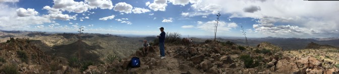
At this point, it was about 2:15 pm. My journey so far had taken all of my estimated time. Being on top of the mountain provided the best cell signal that I had in days, so I sent Gayle a text indicating I made it to the top, and wouldn’t be back until probably 5 pm. The views were spectacular and my pictures don’t do them justice. I have included two panoramic shots to give a 360 degree view of what I saw. I wanted to stay longer than the 30 minutes we did, to enjoy the views and partly because I wasn’t eager to face some of the downward challenges.

Off we went to work our way down. Somehow we ended up on an easier trail down that followed a dried up water fall. The rock was smooth, but it meant we didn’t need to climb down as many of the rocks we had clambered over on the way up. The trek down went much faster than I expected. At the spots on the upward journey where I clung to the rock for my life, it seemed much less daunting. Perhaps the perspective coming down changes the difficulty of the challenge? All I know is that when you can see the path before you, it is much easier and less challenging then when you are unsure of where your next step or handhold will be. I’m not saying that I still didn’t cling to the rock at times when the cliff was on one side of me with only inches to place my feet, but I was confident that I could do it without and problem.
Would I do this again? My original answer was no. But now as I write this, I would say – maybe. If I go again, it will be with a group and without my hiking poles. Perhaps a better pair of shoes also. The rocks were a bit hard on my shoes, and they are a bit ripped on the sides. Challenge yourself and you will gain confidence in yourself.
